 Research Areas > Wetlands > Historical Ecology of Southern California Coastal Wetlands
Project: Historical Ecology of Southern California Coastal Wetlands
Background and Objectives
Numerous reports have indicated that Southern California has experienced among the greatest loss of coastal wetlands of any coastal region in the United States. These losses are often cited as the rationale for wetland protection efforts and ambitious restoration projects. Historic losses have been estimated from a variety of sources, yet no comprehensive map exists detailing the distribution of historical coastal wetlands in Southern California. Furthermore, most prior analyses have addressed overall wetland losses, but have not examined impacts to specific habitat types. Such information is important from a regional restoration planning perspective because it allows managers to identify wetland types and geographic areas that have experienced greatest loss. Knowledge of historical wetland habitat distribution also provides important insight for site-specific restoration design.
The goal of this study is to acquire, georeference, digitize, and interpret 26 priority t-sheets (historical coastal topographic maps), so as to provide an initial estimate of historical conditions at the time the maps were created. It is intended to provide a foundation for more intensive future investigations of the historical ecology of coastal wetlands. These future efforts will require acquisition and interpretation of supplemental, supporting documentation to build upon the initial t-sheet foundation.
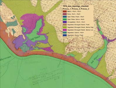
Example of digitized and attributed t-sheet of the Point Hueneme area.
Status
This project was completed in 2010.
Methods
Historical analysis of coastal wetlands requires compilation of multiple independent data sources, so as to provide findings backed by a weight of evidence approach. A critical first step in this process was digitizing and attributing the coastal topographic maps (t-sheets). The t-sheets produced by the US Coast and Geodetic Survey were made between 1850 and the mid-1870s. Although they were produced mainly for navigational purposes, they also offer some of the earliest systematic mapping of Southern California’s coastal wetlands.
The 26 priority t-sheets that were digitized, georeferenced, and attributed for this project were selected by the WRP Science Panel as most representative of coastal wetlands of the Southern California Bight. To the extent practical, researchers used recent, full-color high-resolution scans from the National Oceanic and Atmospheric Administration (NOAA), which provide much higher resolution and detail than the more commonly available scanned images. The selected T-sheets were digitized and georeferenced into a modern coordinate system using appropriate geospatial transformation techniques, including methods used by the USGS National Shoreline Change Mapping Program. Every reasonable effort was made to obtain a high level of accuracy (15 m); however, limitations in image quality and T-sheet surveyor capability precluded this for some T-sheets.
Once digitized, all polygons were attributed with base habitat types as could be reliably interpreted from the t-sheets, including open water (freshwater and saltwater), woody vegetated areas, vegetated intertidal areas, unvegetated intertidal areas (e.g., mudflats), and dunes. These habitat types and their persistence can be refined in the future as additional corroborating evidence is compiled. Historical habitat types will also be related to contemporary habitat classifications to facilitate evaluation of losses and restoration opportunities.
Findings
An interactive website was developed to communicate project findings and offer access to images of the T-sheets with corresponding habitat information overlain on aerial photography. Major findings of the study were:
• There were about 20,000 ha (49,400 acres) of estuarine habitats along the Southern California coast prior to modern development.
• The most common estuarine habitat type was vegetated wetlands (i.e. salt or brackish marsh), followed by subtidal waters and intertidal flats. Salt flat and open water were smaller components of the regional habitat mosaic.
• The subregional distribution of estuarine habitat types was heterogeneous. For example, subtidal waters predominated in one subregion – Mission Bay/Silver Strand. Vegetated wetlands were the dominant habitat type in all other subregions. Salt flat was found predominantly in the San Pedro and Oceanside regions.
• Most of the estuarine habitat area of Southern California was found in a relatively small number of systems. The top 21 systems accounted for 98% of the estuarine habitat area.
• Distinct habitat mixes can be identified among these systems, suggesting a preliminary set of regional coastal estuarine patterns or archetypes. The most common archetype was broad tidal marshes with adjacent intertidal flats and smaller areas of subtidal water, open water, and salt flat. Several other patterns were observed in different physiographic settings.
The T-sheet Atlas and associated geodatabase provide a tool for efforts to understand how Southern California coastal wetland systems work and how they can be best managed over time. Future research should incorporate additional historical and contemporary data sources to better understand early historical conditions, system dynamics, and change through time.
Partners
California State University Northridge (CSUN)
San Francisco Estuary Institute (SFEI)
University of California, Los Angeles (UCLA)
University of Southern California (USC)
This page was last updated on: 7/2/2014