 Research Areas > Bioassessment > Establishing Reference Conditions in Southern California Streams
Project: Establishing Reference Conditions in Southern California Streams
Background and Objectives
Conducting stream and river bioassessment requires initial characterization of "reference" or natural unimpaired sites, which establish baseline benchmarks for expected stream condition. In addition, long-term monitoring at reference sites can aid detection of impacts from large-scale, long-term stressors, such as climate change, wildfires, and aerial deposition of nutrients and metals. This project entailed determining criteria for reference sites, identifying candidate sites, and maintaining a network of high quality reference sites in Southern California for long-term assessment.
This program is a component of a larger statewide effort to monitor reference streams throughout California.
Status
This project was initiated in 2009 and completed in 2013.
Methods
Data from over 2,500 sites throughout California were inventoried; of these sites, bioassessment data were available for 1,985 (Figure 1). Catchments for each site were delineated using geographic information systems. Metrics to calculate land use (e.g., urban land cover, mine density, road crossings) and natural characteristics (e.g., elevation, precipitation, nitrogenous geology) of each catchment were calculated at multiple spatial scales. Sites were then screened using objective criteria for each stressor to identify a network reference sites. Researchers assessed the network against two primary performance criteria: 1) maximization of representativeness, and 2) minimization of stress. Environmental representativeness was evaluated by (1) comparing the distribution of passing reference sites to the full regional ranges of various natural gradients (including elevation, catchment size, precipitation, slope, catchment geology and predicted conductivity) and (2) conducting a principle components ordination that allowed comparison of the coverage of reference sites to the range of environmental diversity in the full data set.
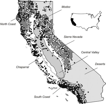
Distribution of 1,985 candidate sites screened for inclusion in California’s reference pool. White circles represent passing sites and black circles represent sites that failed one or more screening criteria. Thick solid lines indicate boundaries of major ecological regions. Lighter dashed lines indicate sub-regional boundaries.
Findings
Of the 1,985 sites screened, 590 met all reference criteria. These sites were found throughout the state, although mountainous regions (e.g., the Sierra Nevada, the South Coast Mountains) were better represented than lower elevation regions. Only one reference site was identified in the Central Valley, but several dozen sites were identified in all other regions. Ordination of environmental gradients using principal components analysis indicated that nearly all stream types present in the state were well represented by the reference data set, except for some of the largest and driest watersheds. This approach is likely to be suitable for a wide range of applications and is easily customizable to particular regional or programmatic constraints.
Partners
This project was conducted in collaboration with the Department of Fish and Wildlife.
Presentation
• Developing a Perennial Reference Stream Network to Support Bio-Objectives (Video) - January 2012 presentation to SCCWRP member agencies describing data analysis to identify reference sites.
This page was last updated on: 6/30/2014